In atmospheric science, it is seldom possible to test hypotheses in a controlled laboratory environment. Instead, we are forced to test hypotheses in the field under uncontrolled conditions. This requires a very different strategy and is certainly more difficult to pull off. Whatever else happens, the experimental design must be capable of disproving the experimental hypothesis. Not all field experiments seek to test hypotheses, of course; some are ``fishing expeditions" designed just to see what is out there.
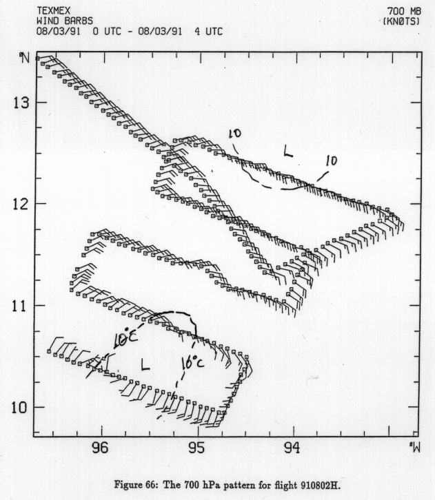
We designed the Tropical Experiment in Mexico (TEXMEX) to test the hypothesis that the development of a mesoscale column of nearly saturated conditions is a necessary and perhaps sufficient condition for the onset of tropical cyclone intensification. For convenience, we shall simply define genesis as the onset of tropical cyclone intensification by the Carnot cycle. The experimental design and results of the project are described in some detail in Bister and Emanuel (1997) [1].
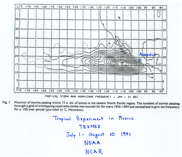
The experiment involved the use of two instrumented aircraft, based in Acapulco, which is on the west coast of Mexico. The eastern North Pacific has the highest number density of tropical cyclones per unit area per unit time of any region of the world, during the months of July and August (Figure 6.7). As virtually all the storms move broadly toward the west, the east-west gradient of the density of tropical cyclones in Figure 6.7 gives a good indication of the rate of genesis. This rate of genesis is maximum a short distance southwest of Acapulco.
To test the experimental hypothesis, we attempted to survey pre-cyclonic cloud clusters during the course of their evolution, as they passed westward to the south of Acapulco, over a period of two or three days. The hope was that roughly half the disturbances would decay while the other half developed, so that one could observe the differences between the two classes of disturbance. In the event, 1991 turned out to be a poor year for eastern North Pacific storms and only four were surveyed adequately. Unfortunately, all four developed into hurricanes, so that no ``control" cases were observed with any degree of thoroughness.
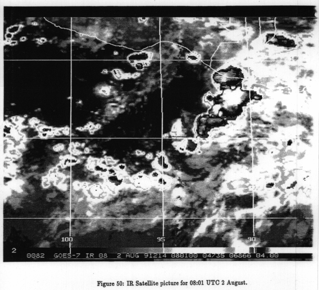
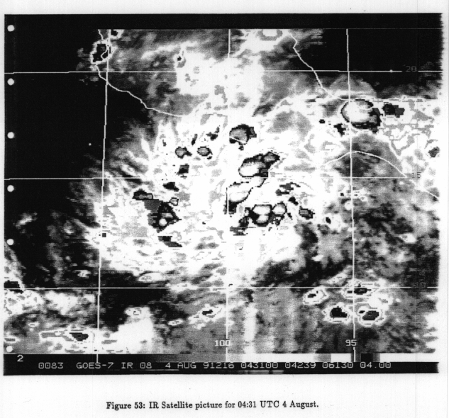
A good example from TEXMEX was the development of hurricane Guillermo, which was surveyed from 3 -5 August 1991. A sequence of satellite-based infrared images of this developing cloud cluster is shown in Figure 6.8a, Figure 6.8b, Figure 6.8c, Figure 6.8d, Figure 6.8eand Figure 6.8f. These images contour the effective emission temperature of the pixel observed. The black background shows the generally high temperature of the surface where there are no clouds. Clouds, particularly thick, high clouds, show up as low emission temperature regions. In the first figure, a broad band of convective storms is moving off the coast of central America, between about 90 W and 94W longitude. This is the feature of interest. At this stage, it has the form of a cloud cluster, elongated perhaps to the extent of being called a squall line. It is moving westward and is associated with an easterly wave in the east-to-west flow. The easterly wave is most in evidence at around the 700 mb level.
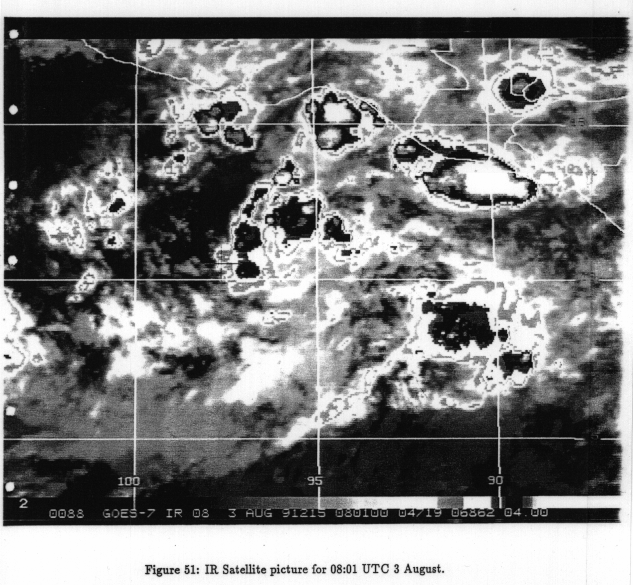
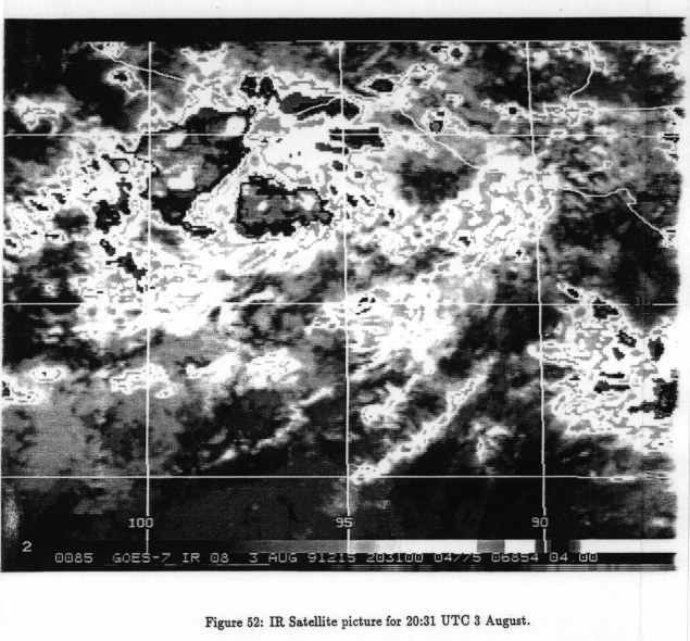
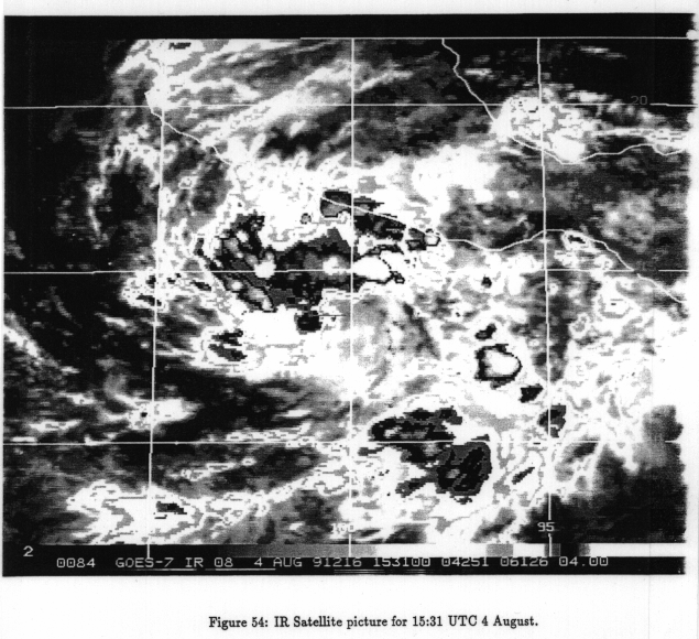
One day later (Figure 6.8b), the cluster, now centered around 96 W, has evidently dissipated somewhat, with cloud top temperatures somewhat warmer than those of a day earlier. (The strong convection just off the coast of Mexico is a diurnal phenomena caused by the flow of chilled, nighttime air from land to sea. The convergence at the leading edge of this air causes convection to erupt just offshore.) By 3 August (Figure 6.8c), the cluster is centered around 98 W, moving steadily west-northwestward. Cloud top temperatures have fallen, and the cluster looks a little more impressive than one day earlier, though still somewhat disorganized. It has the general character of a mesoscale convective complex, a grouping of convective storms that lasts for from 6 hours to several days, though it may not be large enough to meet the technical definition of such as system. Eight hours later (Figure 6.8d), the appearance of the system has changed perceptibly. The average cloud top temperature has warmed, but there are many isolated, very cold cloud tops, indicating the development of quite a few strong convective storms. Also, much of the random convection surrounding the system has dissipated, leaving the system more starkly evident as an entity.
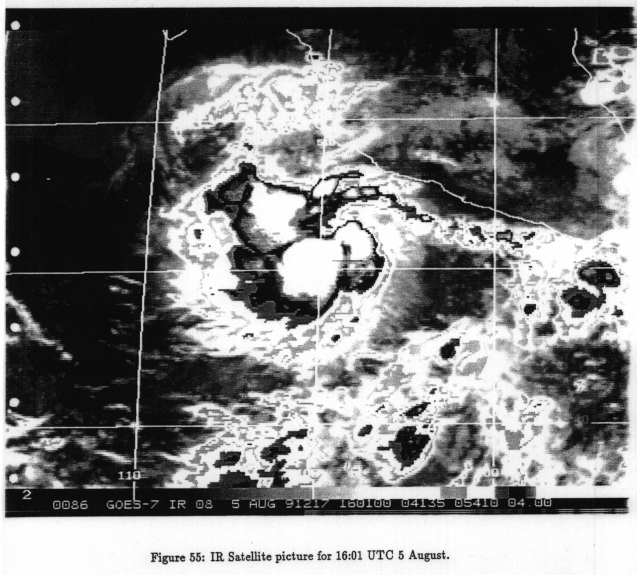
Eleven hours later (Figure 6.8e), the system continues to move west-northwestward and there is more circular symmetry. While some development seems to have occurred, there is not a very great difference in the appearance of the system from 19 hours earlier (Figure 6.8c). But then, by about 1 day later (Figure 6.8f), there is a dramatic development: convection has virtually exploded near the core of the system, with very high, cold cloud tops covering a substantial area. This corresponds very closely with the appearance of a warm-core cyclone at the surface and the ``ignition" of the tropical cyclone, as we shall see presently.
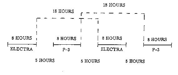
The two instrumented aircraft were flown in an alternating sequence, as shown in
Figure 6.9. This allowed for maximal temporal coverage of the system while
accounting for crew rest considerations, ferry time to the target, etc. The
aircraft made in situ measurements of temperature, wind direction and speed,
water vapor and pressure. The aircraft did not yet have navigation by the
Global Positioning System (GPS), so wind speed and direction was deduced from
airspeed and inertial navigation systems together with LORAN. The accuracy of
the vector wind is usually better than  .
.
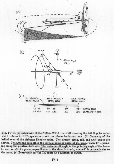
In addition to the in situ measurements, one of the two aircraft (the NOAA WP-3D) was equipped with a Doppler radar mounted in the tail. (It also carried a belly radar which did not have Doppler capability.) As shown in Figure 6.10, the radar scans in a pencil beam rotating around the longitudinal axis of the aircraft. Pulses of radiation are transmitted along the beam and reflect off precipitation particles in the atmosphere. Some of the backscattered radiation is received by the airborne radar. By measuring how much radiation is returned, and correcting for the distance from the radar, one can estimate the density of reflectors and thereby estimate the precipitation content. (The wavelength of the radiation is 5 cm, which is much larger than even the largest precipitation particles. This means that the scattering follows Rayleigh's law, which indicates that the power of the scattered radiation varies as the sixth power of the drop size. Thus the radar ``sees" large precipitation particles and misses altogether the very small droplets that comprise what we call ``cloud".) By measuring how long it takes the pulse to travel to and from the reflectors, we know how far away those reflectors are. Finally, by measuring the Doppler shift of the returned radiation, the component of motion of the reflectors towards or away from the radar is inferred.
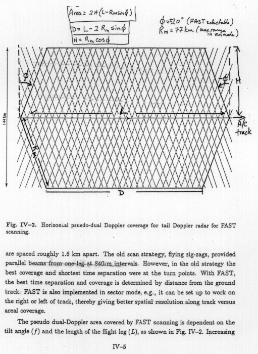
The radar was modified so that rather than scanning in disks, as in Figure 6.10, it scans in cones with axes along the longitudinal axis of the aircraft. A fast switch alternates between forward and backward cones. The resulting pattern of pulse paths is shown in Figure 6.11. In this figure, the aircraft flies along the straight line at the center of the figure. The diagonal lines indicate the paths followed by the radar pulses. The important thing to note is that each patch of atmosphere within radar range of the aircraft is surveyed twice by the radar: once before the aircraft has passed the point in question, and once after it has passed by. Assuming that the true motion of the reflectors does not change between these two radar measurements, we can thereby deduce two horizontal components of the motion of the reflectors. To a very good approximation, the horizontal motion of the reflectors is the same as that of the air in which they are embedded. The third velocity component of the air can be deduced from mass conservation.
Thus a single pass of the aircraft suffices to deduce the three-dimensional air motion on either side of the aircraft track.
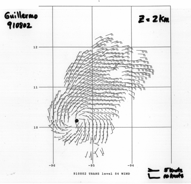
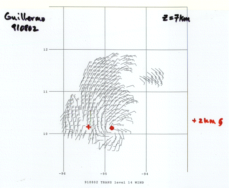
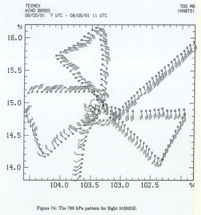
With this in mind, let's look at the evolution of the cloud cluster that became Hurricane Guillermo. Figure 6.12 shows the Doppler winds at 2 km altitude on 3 August 1991 at about 0200 GMT. The flags point into the wind, and the long barbs denote 10 knots (nautical miles per hour...1 knot is very nearly 0.5 m/s), while the short barbs are worth 5 knots. Note the very clear indication of a cyclonic vortex, with overall dimensions of around 100 km. The winds measured directly by the aircraft (Figure 6.13) show the same pattern at 700 mb (about 3 km) and also show that the temperature at this altitude is nearly constant. At 7 km altitude (Figure 6.14), there is also a cyclonic vortex, but it is smaller in dimensions, and located about 40 km to the east of the circulation center at 2 km. At the lowest flight level, about 500 m over the sea surface (Figure 6.15), air flow under the mid-level cyclone is anticyclonic and divergent. The only hint of a cyclonic circulation is far to the southeast of the position of the mid-level cyclone. Air temperatures (black contours) are depressed as are the equivalent potential temperatures (blue contours), which are a measure of the entropy of the air. This scenario is typical of mesoscale convective systems over land or water. The cold outflow is produced when rain falling from a mesoscale anvil system, evident in the satellite imagery in this case, evaporates and thereby chills the air, causing it to sink to the surface. This rain-chilled air originates in the lower and middle troposphere and has a lower entropy than the boundary layer air. This cold air is very stable and resistant to upward displacement, but it is also far from thermodynamic equilibrium with the sea surface. Gradually, contact with the ocean will increase the temperature and humidity (and entropy) of this air.
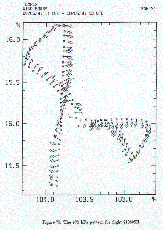
The situation a little more than 24 hours later is illustrated in the next sequence of figures, beginning with Figure 6.16 which shows the aircraft-measured flow at 700 mb. The cyclone at that level has intensified just a bit and moved to the west-northwest. But at the surface, there has been a dramatic change (Figure 6.17): A strong but small-scale cyclone has developed within the cold air, nearly under the center of the circulation at 700 mb. There is also a hint of a local temperature maximum within the otherwise cold air, consistent with the fact that now, in a limited area, the intensity of the cyclone actually decreases upward. Very shortly after this time there is an explosion of deep convection in the IR satellite imagery (Figure 6.8f). This seems to be a crucial phase in the development of the storm: up until this time, the system behaved very much as an ordinary mesoscale convective complex; but the development of a strong, warm-core cyclone inside the cold pool is unusual. We believe that we caught the system in the act of transforming into a tropical cyclone, for 24 hours later (Figure 6.18 and Figure 6.19), the system had all the characteristics of a classical, developing tropical cyclone, with strong cyclonic surface winds and a warm core aloft.
How should we interpret these observations? One limitation of the data, already alluded to, is that the experimental design did not permit detailed observation of the development of the mesoscale convective system. The genesis and maintenance of such systems is still considered an outstanding problem in meteorology. But we may be in a position to say something about the subsequent transformation of the system into a tropical cyclone. Our working hypothesis is that the evaporation of rain falling mostly from the stratiform anvil system served to cool and moisten the mesoscale environment, creating a mesoscale cyclone aloft, where air flows into the downdraft. This results in a mesoscale area of cool, moist air with cyclonic rotation aloft. This in turn serves as an womb for the development of a tropical cyclone, as illustrated by a series of numerical experiments performed by Marja Bister.
These numerical experiments were carried out using the axisymmetric, nonhydrostatic model of Rotunno and Emanuel (1987) [8], described previously. But instead of beginning the integration with a moderate amplitude, warm core cyclone it was started from a state of rest, applying a steady stream of falling precipitation emanating from an artificial ``showerhead" located in the middle troposphere. The showerhead was designed to mimic the observed mesoscale region of stratiform precipitation, with a diameter of roughly 100 km. The showerhead was maintained for 36 hours and then shut off.
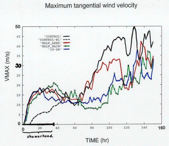
The evolution with time of the maximum azimuthal wind in the domain (whether at the surface or not) is shown Figure 6.20. The black solid shows the control experiment and the black dashed curve shows the maximum wind at the surface. The other curves show the domain maximum wind speed in several other experiments in which the intensity and duration of the imposed rain and the width of the showerhead were varied. All the experiments shows the same basic behavior, however.
Detailed examination of the model output reveals an interesting physical evolution. When the rain shaft is switched on, the falling precipitation partially evaporates, cooling and moistening the air in a mesoscale region. This cold air descends, causing outflow near the surface and inflow in the middle troposphere. The inflow aloft leads gradually to the development of a mesoscale cyclone there, by conservation of angular momentum. During the first 48 hours or so, the maximum wind speed in the system is associated with this mesoscale cyclone aloft, as in the TEXMEX observations. (Note in Figure 6.20 that the maximum surface winds do not coincide with the domain maximum wind until after about 2 days.) An anticyclone also develops at the surface, but surface friction keeps it from becoming very strong. As the cyclone aloft develops, thermal wind balance is nearly maintained, so that the core of the system becomes colder over the same time scale as the cyclone aloft develops. As it becomes colder it becomes more humid as well. This development will cease when the rain shaft is switched off, or when the air in the core becomes saturated, whichever happens first.
Another dynamical process is at work at the same time. While the cyclone aloft develops, it also migrates downward owing to downward advection of angular momentum in the downdraft. While this process cannot by itself create cyclonic wind right at the surface, it does bring the cyclone into close proximity with the surface. At the same time, the air in contact with the ocean has been chilled by evaporating rain. This air is heated at its base by contact with the warm ocean and becomes locally unstable, leading to small-scale convection. (The model does not resolve most of such convection, but contains a turbulence parameterization that turns on when the air becomes unstable.) This small-scale convection mixes momentum right down to the surface and is responsible for the development of a cyclone there, as seen in Figure 6.20.
Now the increasing surface winds further increase the flux of enthalpy from the ocean to the atmosphere. Eventually, this raises the entropy of the boundary layer air to the point that it is unstable to deep moist convection, which breaks out at about 60 hours into the simulation. This convection is occurring in an environment that already has anomalously high cyclonic vorticity, and is also anomalously humid thanks to the evaporation of rain that fell from the showerhead. Consequently, little or no evaporation of rain from the new convection occurs. Convective-scale downdrafts do not develop and so there is no surface outflow. The convection that develops at this stage is highly unusual...it has a simply in, up and out circulation and is largely missing the downdraft branch that characterizes most deep convection. The increasing inflow leads to yet greater enthalpy flux from the ocean, and the Carnot cycle is off and running.
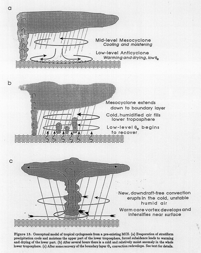
This picture of tropical cyclogenesis is summarized in Figure 6.21. The mesoscale cyclone that develops in the stratified precipitation region of a mesoscale convective system is crucial in two respects: It supplies an initial cyclone, which migrates downward within the mesoscale downdraft and is ultimately mixed right down to the surface by shallow convection, and it humidifies the air within a mesoscale column, so that when new deep convection erupts it produces little or no downdraft.
The pictures painted by the model simulations and the TEXMEX observations of the development of Hurricane Guillermo are consistent and revealing about the nature of tropical cyclogenesis, though they leave unanswered the question of just how mesoscale convective systems develop in the first place. It is tempting to generalize this picture to all cases of tropical cyclogenesis, but observations of other instances of genesis suggest that it may happen very different ways in different cases. These different routes to genesis will only become clear with further detailed observations of the process.