Anthropogenic Effects on Tropical Cyclone Activity
(Revised January, 2006)
Kerry Emanuel
Program in Atmospheres, Oceans, and Climate
Click
Here to return to Kerry Emanuel’s Home page.
Massachusetts Institute of Technology
Part I: Frequently asked questions
I. Frequently Asked Questions about Global Warming and Hurricanes
1.) Q: Is global warming causing more hurricanes?
A: No. The global, annual frequency of tropical cyclones (the generic, meteorological term for the storm that is called a tropical storm or hurricane in the Atlantic region) is about 90, plus or minus 10. There is no indication whatsoever of a long-term trend in this number.
2.) Q: But I’ve noticed that there seem to have been lots more hurricanes, beginning around 1995.
A: You probably live in
3.) Q: Is the intensity of hurricanes increasing with time?
A: There is some evidence that it is. Records of hurricane activity worldwide show an upswing of both the maximum wind speed in and the duration of hurricanes. The energy released by the average hurricane (again considering all hurricanes worldwide) seems to have increased by around 70% in the past 30 years or so, corresponding to about a 15% increase in the maximum wind speed and a 60% increase in storm lifetime.
4.) Q: But aren’t there lots of errors in the hurricane record?
A: Yes, there are. Reliable records of wind speeds in hurricanes over the open ocean go back only to around 1950, when aircraft reconnaissance of hurricanes began over the North Atlantic and western North Pacific; before that, the only good measurements of wind speed were made when hurricanes made landfall or passed over islands or ships with measuring equipment. Unfortunately, methods of measuring or estimating wind speed from aircraft have evolved over time, and these changes were not always well documented. Since about 1980, there are wind estimates for all hurricanes globally, based on satellite images, but these are not as good as aircraft measurements.
5.) Q: Then how can you determine trends with such data?
A: Fortunately, the means of estimating the central surface pressure in hurricanes have remained fairly constant with time. In practice, central pressure is well correlated with maximum wind speed, and therefore can be used to detect changes in the way winds were estimated from pressures. Also, in a large enough sample of events, the wind speeds are well correlated with a quantity call the “potential intensity”, which is a function of the temperature of both the ocean and atmosphere. We have fairly good records of the information needed to calculate potential intensity, and so can compare estimated wind speeds with estimated potential intensity for large enough samples. This is another check on the quality of the wind estimates. Even in the Southern Hemisphere, where there have never been aircraft observations of hurricanes, the satellite-based estimates compare well with estimates of potential intensity.
6.) Q: You say that reliable records of hurricane wind speeds go back only to about 1950, so how can you say that there were not even more intense storms before 1950? How can you assert that the upswing in the last 50 years is a consequence of global warming?
A: We cannot say for sure. What we can say is that everywhere we have looked, the change in hurricane energy consumption follows very closely the change in tropical sea surface temperature. When the sea surface temperature falls, the energy consumption falls, and conversely, when it rises, so too does the energy consumption. Both theory and models of hurricane intensity predict that this should be so as well. In contrast to the hurricane record, the record of tropical ocean temperature is less prone to error and goes back 150 years or so. Moreover, geochemical methods have been developed to infer sea surface temperature from corals and from the shells left behind by micro-organisms that live near the surface; these can be used to estimate sea surface temperature for the past several thousand years. These records strongly suggest that the 0.5 degree centigrade (1 degree Fahrenheit) warming of the tropical oceans we have seen in the past 50 years is unprecedented for perhaps as long as a few thousand years. Scientists who work on these records therefore believe that the recent increase is anthropogenic.
7.)
Q: Does this mean that we are
seeing more hurricane-caused damage in the
A: There is a huge upward trend in hurricane damage in the
8.) Q: I gather from this last discussion that it would be absurd to attribute the Katrina disaster to global warming?
A: Yes, it would be absurd.
9.) Q: OK, maybe we won’t see global warming effects in landfalling hurricanes for another 50 years or so, but shouldn’t we still be worried about it?
A: The answer to this question is largely a matter of one’s
geographical and time horizons. For U.S.-centric concerns over the next 30-50
years, by far the most important hurricane problem we face is demographic and
political. Consider that Katrina, as horrible as it was, was by no means
unprecedented, meteorologically speaking. More intense storms have struck the
On the other hand, if one’s view is not confined to the
1. Introduction
Among the more consequential effects of global climate change is a possible change in tropical cyclone activity. We are most concerned with three aspects of hurricane activity: their frequency, their intensity, and their geographical distribution. Any change in the frequency with which hurricanes strike populated land is of obvious concern. But the amount of damage increases roughly as the cube of the maximum wind speed in storms, so in practice we are concerned more with intense storms. If some aspect of climate variation were to lead to fewer hurricanes, but more intense ones, we might expect more losses. We would also be concerned if climate change were to cause hurricanes to be experienced in parts of the world now free from them, or to cease to be experienced in regions they now trouble. From a scientific standpoint, these issue are quite separate. The factors that control the intensity of hurricanes appear to be quite different from those that govern their frequency of occurrence, and this is reflected in the observation that some seasons produce very few but very intense storms. (The 1992 season had few storms, but it produced Hurricane Andrew.)
The geographical distribution of hurricanes over a statistically large sample is determined by features of the large-scale circulation of the atmosphere and oceans which can, in principle, be simulated by global circulation models.
A fourth characteristic of hurricanes, their geometric size, has received less attention. The diameter of tropical cyclones ranges over nearly a factor of ten: the smallest observed storms can be placed entirely within the eyes of the largest. A storm whose radial dimension is twice the size of another will cause perhaps as much as four times the damage (all other things being equal) since the damage track will be twice as wide and each point within it will experience damaging winds for twice as long. The magnitude and area covered by oceans waves and the storm surge will also be greater. Katrina of 2005 is a grim example of a large hurricane. But so little is now known about the factors that determine the geometric size of individual storms that we are not able to discuss the matter here. In the following sections, we focus instead on the factors affecting the intensity, frequency and geographical distribution of hurricanes. We then present some empirical evidence for changing hurricane activity. Finally, we discuss new efforts to empirically relate tropical cyclone activity to climate by reconstructing past storm activity from the geological record.
2. Intensity
The intensity of an individual hurricane, as measured conventionally by its maximum surface wind speeds or minimum surface pressure, is affected at any given time by a large and complex array of physical processes governing the interaction of the storm with the underlying ocean and with its atmospheric environment. Few of these processes are well understood. For a given ocean temperature and atmospheric thermodynamic environment, there is an upper bound on the intensity that a storm may achieve, but very few storms achieve this bound in practice. (For a more complete discussion of the theory of limiting intensity, click here.) Although very few actual storms achieve their limiting intensity, it turns out that when a large enough sample of events is considered, the distribution of intensities scales very nicely with the limiting intensity (hereafter referred to as the potential intensity), as shown by Emanuel (2000). This means that a percentage change in the potential intensity implies that, over a large enough sample, the intensity of hurricanes should change, on average, by the same percentage.
There are reasons to be concerned that the anthropogenic addition of greenhouse gases to the atmosphere might lead to an increase in the energy available to tropical cyclones and therefore to an increase in their potential intensity; these are discussed in a previous paper by the author (Emanuel, 1987). Greenhouse gases reduce the amount of infrared radiation leaving the earth's surface, and unless there is a compensating decrease in the amount of solar radiation reaching the surface by clouds (but this is complicated because clouds also trap outgoing infrared radiation), the ocean must lose the excess heat by increased evaporation of sea water. There are only two ways to achieve this: either the thermodynamic disequilibrium between the tropical oceans and atmosphere must increase or the average surface wind speed must increase. If the thermodynamic disequilibrium increases, then so does the potential intensity of hurricanes (unless the thermodynamic efficiency were to decrease, but in fact, the efficiency also increases when greenhouse gases are added to the atmosphere. Not only does the input temperature (the sea surface temperature) increase, for the reasons given above, but the temperature of the tropopause decreases, because the extra greenhouse gas at high levels leads to more efficient emission of infrared radiation and thus to more cooling).
If the average wind speed near the surface of the tropical oceans does not change, theory predicts that the wind speeds in hurricane should increase about 5% for every 1oC increase in tropical ocean temperature (Emanuel, 1987). Computer models confirm this tendency, but assign a slightly smaller magnitude of the increase (Knutson and Tuleya, 2004).
There is some uncertainty, however, about the magnitude of the increase in potential intensity of hurricanes accompanying increases in anthropogenic greenhouse gases. The main source of uncertainty plaguing calculations of the increase have to do with uncertainties in predicting global warming itself; these have to do with feedback processes in the climate system, especially those involving water vapor and clouds. the principal feedback in the climate system: the amount of water vapor in the atmosphere. Were water vapor content and cloudiness to remain fixed, doubling atmospheric carbon dioxide would yield a tropical sea surface temperature increase of only about 0.5 C and a barely perceptible rise in the potential intensity of tropical cyclones. Most climate model simulations give much larger increases than this, owing to a positive feedback loop involving increasing atmospheric water vapor. But the physics of the processes controlling water vapor in the atmosphere are poorly understood and even more poorly represented in climate models, and what actually happens in the atmosphere is largely unknown because of poor measurements. It is now widely recognized that improvements in understanding and predicting climate hinge largely on a better understanding of the processes controlling atmospheric water vapor and clouds.
Among the environmental factors known to affect hurricane intensity is vertical wind shear. This is just the rate at which the background horizontal wind varies with altitude. Even modest magnitudes of shear prevent weak disturbances from intensifying and may also limit the intensity of mature storms. Vertical shear affects the storm dynamics in numerous ways, few of which are well understood. It acts to tilt the circulation of the storm, possibly disrupting the flow of air in, up and out through it. Also, through a complex dynamical interaction, it forces a couplet of up-down motion, straddling the storm center. This in turn causes an asymmetrical distribution of clouds and rain and may also disrupt the essential process of heat transfer from the ocean, which is particularly important under the eye wall. Finally, vertical shear causes dry air from the environment to penetrate inward closer to the core of the storm. This may lead to the formation of cold, dry downdrafts in the eyewall, partially or completely offsetting the critical moistening of the boundary layer air by the ocean.
Not all dynamical
interactions of tropical cyclones with their environment are detrimental to
storm intensity. Tropical meteorologists in the 1940's noticed that
interactions between cyclones and certain features of the flow at very high
altitudes could cause intensification. Work by Bosart and
Bartlo (1991) and by Molinari et al. (1995) have recast the analyses of
such interactions in a modern dynamical framework, making the physics of the
interaction somewhat more clear. It appears from this work that, under the
right circumstances, the approach of a high altitude cyclonic circulation can
cause an existing tropical cyclone to intensify, or a nascent one to develop.
There are also several examples of strong high level cyclonic anomalies leading
to the development of strong surface cyclones with some of the characteristics
of tropical storms, even over relatively cool ocean water. One such storm
occurred over the western
Interaction of hurricanes with the underlying ocean can cause substantial reduction of the storm's intensity. This has now been well documented in modeling studies (e.g. Khain and Ginis, 1991; Schade and Emanuel, 1999). Hurricanes stir cold water up to the surface, reducing the amount of heat that flows into the storm. The magnitude of the effect depends on the thickness of the warm layer of water at the top of the ocean, on the forward speed of the storm, and on its geometric size. Typical reductions of intensity from the potential intensity are on the order of 30%.
Clearly, there are many and diverse processes that affect the intensity of individual hurricanes. We would like to know how all of these affect the statistical distributions of hurricane intensity in a given climate, but this will require a far better understanding of hurricane dynamics than we have at present. One factor limiting progress is the enormous computational demands of simulating in three dimensions the full array of scales and physics that characterize tropical cyclones. Computers are barely fast enough to simulate the interaction of a hurricane with its environment with a spatial resolution sufficient to simulate the individual cumulonimbus clouds that are the real agents of vertical heat transport in hurricanes. But we can expect vast improvements in computer capability, if the recent past is any guide.
3. Frequency
Very few atmospheric processes are as poorly understood as tropical cyclogenesis. In spite of years of study, it remains largely a matter of guesswork as to whether a particular tropical disturbance will become a hurricane. Thanks largely to the work of Gray (e.g. Gray, 1988), we now know the atmospheric conditions that must prevail for genesis to occur, but the existence of such conditions, which are not uncommon in the tropics, is by no means a guarantee of genesis. It has been known for many years that tropical cyclones do not arise spontaneously, as do other types of storms, but must literally be triggered by disturbances of independent origin. The frequency of tropical cyclogenesis is a product of the prevalence of Gray's necessary conditions and the frequency of suitable initiating disturbances. But we do not yet know what makes one potential initiating disturbance suitable and another unsuitable.
Some recent developments do offer hope, however, that we may soon understand genesis well enough to be able to predict the statistical frequency of cyclone occurrence given the state of the climate. One such development is the detection by Landsea and Gray (1992) of certain strong empirical relationships between Atlantic hurricane activity and other signals in the climate system. The existence of such signals clearly offers clues about the physics of genesis, but these clues have yet to be unraveled. Another development stems from some recent work with numerical hurricane simulation models and from a series of field experiments performed in the early 1990's in the western and eastern tropical Pacific. It appears that a necessary and perhaps sufficient condition for genesis is the establishment of a pillar of very humid air that extends through the entire depth of the tropical troposphere and is about 50-100 miles wide. (Normally, the tropical atmosphere is somewhat dry in middle levels.) Thunderstorms that then develop within this humid pillar do not produce the dry, cold downdrafts that characterize most such storms and which oppose the tendency of evaporation from the ocean to humidify the atmosphere. These cold, dry downdrafts are driven by the partial evaporation of falling rain, but within the humid pillar, evaporation is reduced and downdraft formation is inhibited. The formation of these humid pillars appears to be possible through a number of different mechanisms, including the lifting of the tropical boundary layer within a tropical disturbance such as an easterly wave. Humid pillars also form naturally within tropical cloud clusters, by mechanisms that have yet to be elucidated.
The problem of predicting how tropical cyclone frequency might respond to climate change can be broken into two parts: predicting how the prevalence of Gray's necessary conditions will change, and predicting how the frequency and strength of potential initiating disturbances will change. Elementary considerations suggest that anthropogenic increases in greenhouse gases will reduce the former and increase the latter. Very briefly, the strength of very large scale tropical circulations such as monsoons and the trade winds are expected to increase. (Although the pole-to-equator surface temperature gradient decreases, gradients at higher altitudes increase and, in the net, the strength of thermally direct circulations increases.) In general, this would be accompanied by an increase in vertical wind shear, particularly in the upper troposphere (wind shear in the lower troposphere actually decreases). This would weigh in favor of fewer cases of tropical cyclogenesis. On the other hand, the more vigorous large-scale circulation might favor more and stronger potential initiating disturbances, such as easterly waves. This would weight in favor of more tropical cyclones. Thus the problem is complex, and simple reasoning produces ambiguous results.
Our group at MIT has recently updated Gray’s genesis index approach, using potential intensity, relative humidity, low-level vorticity, and deep tropospheric wind shear as predictors. We developed a new index, described in a preprint for the 26th Conference on Hurricanes and Tropical Meteorology in 2004 (available by clicking here). This index does a good job predicting the both the seasonal cycle and the geographical distribution of hurricane genesis, as illustrated here.
Global climate models (GCMs) have been used by a number of groups to explore changes in tropical cyclone activity in a double CO2 world. To date, each of these groups has examined changes in the activity of tropical cyclones produced explicitly by the models. This approach is problematic, because neither the spatial resolution nor the physics of the models is sufficient to simulate tropical cyclones scrupulously. While the physics of mature model storms may be close to that of real hurricanes, it is very unlikely that genesis, which recent field experiments show to occur on scales as small as 30 miles, is being mimicked at all realistically by the GCMs, whose spatial resolution is more like 200 miles. For what they are worth, the GCMs produce conflicting results. The study of Haarsma et al. (1992), using the GCM run by the British Meteorological Office, shows an increase in both the intensity and frequency of tropical cyclones, but the analysis by Broccoli and Manabe (1990), using the Princeton/GFDL model, shows ambiguous results, with an increase in tropical cyclone activity if cloud-radiation feedback is not included and a decrease in activity otherwise.
Perhaps a better strategy would be to use GCMs to assess trends in the empirical genesis index described above. This would circumvent the need to actually simulate genesis and would be within the bounds of what the models should be capable of.
I believe that a thorough, physically-based understanding of tropical cyclogenesis is a prerequisite for developing an ability to relate tropical cyclone frequency to the state of the climate. Empirical studies are enormously useful, but cannot lead to a completely general understanding of the problem. Even so, it must be admitted that such studies are far ahead of theory and modeling, which must now make an effort to catch up.
4. Geographical Distribution
In the current climate, hurricanes develop over tropical ocean waters whose sea surface temperature (SST) exceeds about 26 C, but, once developed, they may move considerably poleward of these zones. An oft-stated misconception about tropical cyclones is that were the area enclosed by the 26 C SST isotherm to increase, so too would the area experiencing tropical cyclogenesis. Regions prone to tropical cyclogenesis are better characterized as places where the atmosphere is slowly ascending on the largest scales. Since about as much atmosphere is descending as ascending, it is hard to change the total area experiencing ascent. Thus there is little basis for believing that there would be any substantial expansion or contraction of the area of the world prone to tropical cyclogenesis. This is borne out by the GCM simulations performed by Haarsma et al. (1992), who show that while there is a substantial increase in the area enclosed by the 26 C SST isotherm is a double CO2 environment, there is no perceptible increase in the area experiencing tropical cyclones.
It is conceivable, though, that changes in the large-scale circulation of the atmosphere would increase or decrease the rate of movement of tropical cyclones out of their genesis regions and into higher latitudes. It is also likely that changes in atmospheric circulation and SST distribution within the tropics would be associated with variations in the distribution of storms and of the tracks they follow, thus affecting the locations and frequency of landfall.
5. Empirical Evidence for Increasing Tropical Cyclone Activity (and a response to its critics)
Examination of the historical record of hurricanes worldwide reveals that a measure of tropical cyclone power dissipation (proportional to the cube of the surface wind speed integrated over the lifetime of each storm) has increased very significantly over the past 30-50 years. This increase is highly correlated with tropical sea surface temperature. Details of the analysis are reported in Emanuel (2005), available here with supplementary information available here. This work implies that global tropical cyclone activity is responding in a rather large way to global warming.
An analysis of this kind requires a very careful treatment of the historical hurricane data, because methods of estimating wind speeds in hurricanes have evolved over the years. The analysis itself is discussed in some detail in the aforementioned Nature paper and its online supplement. Much of the ensuing criticism of this work rightly focuses on the treatment of the data. Here are a few responses to some of this criticism, and a presentation of a further refined analysis.
1. Some storms in the 1950s and 1960s were neglected in the analysis.
Response:
Not true,
2. The wind speed in storms prior to 1970 were reduced as part of the analysis; without this correction, there is no indication of a global warming signal.
Response: Although not usually stated as such, this comment pertains only to Atlantic storms, that constitute only 11% of all tropical cyclones. If one had to rely on ONLY the Atlantic hurricane record, and without considering its correlation with sea surface temperature, it is doubtful that one could make any connection with global warming, with or without the correction to the data. As for that correction, it was based entirely on work by Chris Landsea (Landsea, 1993). Chris and I have talked about this since then, and we both agree that the correction was probably a little too large. I have since implemented a different, smaller correction. In addition to comparing the wind data to the surface pressure data (as discussed in the Nature paper), another test is to compare the histograms of storm intensity, normalized by potential intensity, before and after 1970. In principle, the shape of the histogram should be approximately invariant under climate change. The figure below compares the post-1970 Atlantic histogram with histograms based on both the uncorrected and newly-corrected pre-1970 storm data.
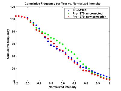
The new correction clearly brings the pre-1970 histogram into better alignment with the post-1970 histogram.
3. There were large changes in the way wind speeds have been measured in western North Pacific hurricanes.
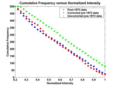
Response: True, and these were accounted for as described in the Nature paper, after spending months going through the raw aircraft data and speaking with some of the people responsible for collecting and analyzing that data. My correction included a consideration of the shift from aircraft-based to satellite-based intensity estimation that occurred in 1987. The graph below compares the cumulative frequency distributions of post-1973 western North Pacific data with both corrected and uncorrected pre-1973 data (going back to 1949). This supports the validity of the correction, and is another indication that reported wind speeds early in the record were much too large.
4. In the presentation of
the graphs, a 1-2-1 filter was applied
twice, but the two end points at each end of the series were retained. They
should have been omitted. This leads to an exaggeration of the upward trend in
the past two years.
Response: The criticism that
the end points were retained in the filtered time series is valid, and indeed, the
upward trend in the past two years is exaggerated in the Atlantic because of this. In
the western North Pacific, however, the trend is underestimated, because there
was a downward trend in the last two years (2002-2003) used in the graphs. The
western North Pacific has about three times as many storms as the North Atlantic . In what follows, I
have omitted the two points at each end of the times series, as is proper.
5. The trend has been downward in other ocean basins not reported in the study.
Response: The trend in the last
few years has indeed been downward in the eastern North Pacific and the
northern Indian Ocean . The latter, however, has a very small
number of storms with small storm track lengths and contributes insignificantly
to the global total. The Southern Hemisphere, which like the Indian Ocean , only has wind speed
estimates going back to about 1980; during this time the trend in PDI is definitely upward.
The graph
below shows the PDI of the North Atlantic , eastern North
Pacific, and western North Pacific combined, with the new correction to the
Atlantic data and the two endpoints omitted from each end of the time series.
As in the Nature paper, this is compared to tropical sea surface
temperature from the Hadley Center
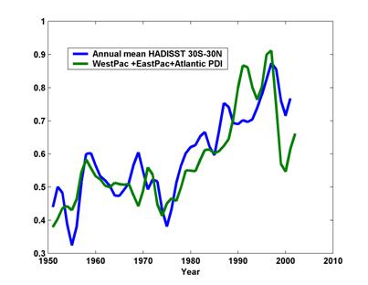
The upward
trend in both SST and PDI beginning around 1975 is significant. The graph below
shows that the two time series are correlated, with an r2 of about
0.67. Given the very active 2003-2005 seasons in the Atlantic , and 2004 season in
the western North Pacific, my guess is that this upward trend is continuing.
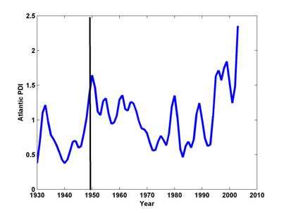
6. You made the trend look large and positive by starting your time series at a relative minimum of activity
Response: Not true. I chose
1949 as the starting point because it was the earliest year I deemed aircraft
estimates of hurricane wind speeds reliable, and because there are no reliable
records in the western North Pacific much before this. We do have some
records in the Atlantic prior to 1949, though. Using
these in a calculation of PDI otherwise identical to that presented in the Nature
paper results in this graph of smoothed Atlantic PDI versus time. The
black vertical bar shows the starting point for the times series in the Nature
paper. This shows that my starting year was a relative maximum of
activity, thereby leading, if anything, to an underestimate of the
long-term trend.
7. Once changes in
population and wealth have been accounted for, there is no significant trend in
damage from U.S.
Response: Yes,
and an analysis of the wind speeds at landfall of U.S. U.S. North Atlantic is .69 with a standard
deviation of .41, whereas the real slope (imposed here) is 0.75. Thus, with
some margin of error, we can detect a trend in Atlantic-wide PDI. But
when the same procedure is applied just to wind speeds at landfall in the U.S. U.S.
6. Paleotempestology
In the past few decades,
several efforts have been initiated to use geological records to quantify
tropical cyclone activity going back as far as the end of the last glacial
episode, about 10,000 years ago. One such effort, described by Liu and Fearn
(1993), is based on the record of hurricane activity in sediments in the bottom
of near-shore freshwater lakes. When Category 4 or 5 hurricanes pass over such
lakes, ocean water breaches the sandbars that separate the lakes from the sea,
leaving a deposit of relatively coarse sediments in the lake bed. Sediment
cores extracted from the lake bed reveal episodic layers of coarse sediments
which can then be dated using carbon 14 techniques. The most recent of these
layers correspond exactly to known historical category 4 and 5 hurricanes. To
date, this technique has only been applied using sediment cores from
Although the long term
record of intense hurricane activity at one point on the shores of the
Tropical cyclones also cause strong currents that affect sediments in shallow ocean water. Records of these sediments can then be dated and used to infer past tropical cyclone activity (Keen and Slingerland, 1993). Although this technique has not been widely applied to date, it appears that it may be possible to use it to construct very long-period records of tropical cyclone activity.
Another technique that
has been developed recently involves an aspect of hurricane rainfall that has
received comparatively little attention. In the 1980's, it was discovered that
rainfall from the eyewalls of tropical cyclones have relatively little
concentration of the oxygen isotope 18O compared to normal tropical
rainfall (Lawrence and Gedzelman, 1996). This is probably a result of the
unusually small rates of evaporation of eyewall rain, given the nearly
saturated environment through which the rain falls. (Evaporation concentrates 18O
in the liquid water left behind.) David Malmquist (Personal communication,
1996) has shown that the oxygen isotope ratio of rainfall can be recorded in
the carbonate deposits in cave stalactites, which can then be sectioned and 14C
dated. He has performed analyses of stalactites in
The field of paleotempestology is in its infancy, but there is hope that it can be used to push back the record of tropical cyclone activity well into the prehistoric past. This may offer the best hope for an empirical deduction about the relationship between tropical cyclones and climate.
7. Summary
The theory of tropical cyclones, in its present state of development, yields some useful insights into the relationship between tropical cyclone activity and climate. There is a rigorous upper limit to the intensity that hurricanes can achieve, and this limit can be easily determined from known states of the atmosphere and ocean. Elementary considerations show that this limit increases with the amount of greenhouse gas in the atmosphere, but the magnitude of the increase that would result from the present injection of anthropogenic greenhouse gases into the atmosphere is unknown, owing to large uncertainties about feedbacks in the climate system. Moreover, very few storms approach their limiting intensity, and the processes responsible for keeping storm intensities below their limiting value are poorly understood and not likely to be well simulated by present GCMs. The frequency with which tropical cyclones occur is a product of the prevalence of known necessary conditions for their formation and the frequency and strength of disturbances that have the potential of initiating tropical cyclones. Neither basic theory nor numerical climate simulation is well enough advanced to predict how tropical cyclone frequency might change with changing climate, and both give conflicting results on the change of tropical cyclone frequency on doubling atmospheric . There is no physical basis, however, for claims that the total area prone to tropical cyclogenesis would increase. The new field of paleotempestology entails the use of a variety of techniques for deducing the long-term history of hurricane activity from the geological record. Pushing the record of landfalling tropical cyclones well back into prehistory, perhaps even to the last ice age, may be the key to understanding from an empirical standpoint the relationship between tropical cyclone activity and climate. We should do what we can to encourage this endeavor.
A detailed examination of
the historical record of hurricanes shows a pronounced upward trend in a
measure of the total power generated by hurricane over the past 50 years. This
trend, and other variations in the power dissipation index, are well correlated
with trend and variability in tropical sea surface temperature, whose upward
swing in the last 30 years appears to be unprecedented over the last several
thousand years. This suggests that the global upward trend in tropical cyclone
activity is a consequence of global warming. Although the upward trend in
hurricane activity is statistically significant, the global data on which this
is based is about 500 times larger than the database covering landfalling
storms in the
Further progress in confronting the important relationship between tropical cyclone activity and climate will be limited unless there are fundamental advances in understanding the basic physics of hurricanes. An important limitation to making such advances is social and political in nature: There are remarkably few scientists working on the problem (when compared to the numbers working on, say, earthquakes, a phenomenon of comparable social significance). This is a complex matter of history and of the professional tastes that guide scientists in their choice of research problems. There is a potential for accelerating progress by taking measures to attract more scientific interest to the problem.
References
Bosart, L.F. and J.A. Bartlo, 1991: Tropical storm formation in a baroclinic environment. Mon. Wea. Rev., 119, 1979-2013.
Broccoli, A.J. and S. Manabe, 1990: Can existing climate models be used to study anthropogenic changes in tropical cyclone climate? Geophys. Res. Lett. , 17, 1917-1920.
Emanuel, K.A., 1987: The dependence of hurricane intensity on climate. Nature, 326, 483-485.
Emanuel, K. A., 2000: A statistical analysis of tropical cyclone intensity. Mon. Wea. Rev., 128, 1139-1152
Emanuel , K. A., 2005: Increasing destructiveness of tropical cyclones over the past 30 years. Nature, 436, 686-688
Gray, W. M. 1988: Environmental influences on tropical cyclones. Aust. Met. Mag., 36, 127-139.
Haarsma, R.J., J.F.B. Mitchell and C.A. Senior, 1992: Tropical disturbances in a GCM. Climate Dyn., 8, 247-257.
Keen, T. R., and R.L. Slingerland, 1993: Four storm-event beds and the tropical cyclones that produced them: A numerical hindcast. J. Sed. Petro., 63, 218
Khain, A., and I. Ginis, 1991: The mutual response of a moving tropical cyclone and the ocean. Beitr. Phys. Atmosph., 64, 125-141.
Knutson, T. R. and R. E. Tuleya, 2004: Impact of CO2 -induced warming on simulated hurricane intensity and precipitation: Sensitivity to the choice of climate model and convective parameterization. J. Climate, 17, 3477-3495
Landsea,
C.W., and W. M. Gray, 1992: The strong association between western
Landsea, C., 1993: A climatology of intense (or major) Atlantic hurricanes. Mon. Wea. Rev., 121, 1703-1714
Liu,
K-B, and M. L. Fearn, 1993: Lake-sediment record of late Holocene hurricane
activities from coastal
Molinari, J., S. Skubis and D. Vollaro, 1995: External influences on hurricane intensity. Part III: Potential vorticity evolution. J. Atmos. Sci., 52, 3593.
Schade, L. R. and K. A. Emanuel, 1999: The ocean's effect on the intensity of tropical cyclones: Results from a simple coupled atmosphere- ocean model. J. Atmos. Sci., 56, 642-651